John Muir Trail - Yosemite to Mt. Whitney - 230 miles, 370 km - Aug 2021

The John Muir Trail (JMT) in California is a famous long-distance hiking trail in the Sierra Nevada mountain range of California, passing through Yosemite, Kings Canyon and Sequoia National Parks and the Inyo National Forest.
From the northern terminus at Happy Isles in Yosemite Valley and the southern terminus located on the summit of Mount Whitney, the trail's length is 211 miles, with a total elevation gain of approximately 50,000 feet (15,000 m). For almost all of its length, the trail is in the High Sierra backcountry and wilderness areas. For about 160 miles (260 km), the trail follows the same footpath as the longer Pacific Crest Trail.
The trail is named after John Muir, a naturalist. John Muir (1838 - 1914) also known as "John of the Mountains" and "Father of the National Parks", was an influential Scottish-American naturalist, author, environmental philosopher, botanist, zoologist, glaciologist, and early advocate for the preservation of wilderness in the United States of America. His writings resulted in creation of the Yosemite National Park in 1890, The work to create JMT started in 1884 and ended in 1938, a truly forward thinking project at that time.
Table of Contents
Jump to relevant sections in the blog using the links below.
Our JMT Trip Summary
7 of us started the JMT on Wed, Aug 11, 2021 and 6 completed the hike in 20 days on Mon, Aug 30, 2021. Team members were Jai Rawat, Ankur Zindal, Ashutosh Chauhan (San Francisco Bay Area), Arun Kumar (Seattle), Meenal Patwardhan (Washington DC), Anuradha Palnitkar, Samir Palnitkar (India). Arun had to leave after 6 days due to a family medical requirement. The remaining 6 completed the trek on Aug 30.

Including everything, we ended up walking 230 miles (370 km) over some of the most strenuous terrain we have ever encountered. Here is a route map. We started at Happy Isles in Yosemite and ended at Mt. Whitney (14,505 ft), the tallest mountain in the 48 contiguous United States.

Quick JMT Highlights
Distance Covered: 230 miles (370 km). Official distance is 211 miles from Yosemite to the top of Mt. Whitney but one has to then descend 11 miles from the summit to Whitney Portal. We also added a side trip to the top of Half Dome which added another 7 miles. This made our total distance 230 miles.
Elevation Gain/Loss: 50,000 ft gain (That's 1.7x Mount Everest!), 46,000 ft loss. 11 passes with increasing difficulty.
Days Needed: We had planned for 21 days but finished it in 20 days
Average Daily Stats: 11.5 miles (18.5 km) of walking every day with 2,500 ft of climbing and 2,300 ft of descending with a 40lb+ (~20kg) backpack. That's like covering a half marathon distance everyday, going up and down the mountains at high altitude while carrying a heavy check-in bag!

Easy Resources
Summary Blog: My friend Jai Rawat has written a fantastic JMT summary blog that is a quick 10 min read. I credit a lot of the material from these above highlights and the slideshow to content that he originally created. Jai has also written a detailed day by day summary blog.
Relive Video: Jai Rawat has also created a beautiful 6 min video that traces the entire 20 day journey, its terrain and photos on a 3D map.
PowerPoint Slides: Here is a summary slideshow presentation if you want to just flip through the JMT slides. Again, I credit Jai Rawat for creating some of this slideshow content. I have put the PPT on Slideshare.
Video Presentation: Here is a 47 min video presentation if you are interested in hearing about our John Muir Trail trip. Youtube Video Link.
Detailed Day by Day Itinerary
If you are interested in the details of what we did each day, please go through the rest of the blog. But the description tends to get rather long! Click on the blue daily links below to jump to that particular day.
Here was our 20 day itinerary with approximate mileage:
Day 0: SFO Bay Area to Curry Village, Yosemite Park
Day 1: Curry Village to Little Yosemite Valley (with Half Dome) (13 miles)
Day 2: Little Yosemite Valley to Sunrise Meadows (10 miles)
Day 3: Sunrise Meadows to Tuolumne Meadows (10 miles)
Day 4: Tuolumne Meadows to Upper Lyell Canyon Creek (11.2 miles)
Day 5: Upper Lyell Canyon Creek to Shadow Lake (14.6 miles)
Day 6: Shadow Lake to Reds Meadows (Mammoth Lakes) (11.6 miles)
Day 7: Reds Meadows to Purple Lake (13.6 miles)
Day 8: Purple Lake to Mott Lake Junction (12.7 miles)
Day 9: Mott Lake Junction to Bear Creek Trail (14.2 miles)
Day 10: Bear Creek Trail to Muir Trail Ranch to Piute Creek (13.3 miles)
Day 11: Piute Creek to Evolution Lake (11.5 miles)
Day 12: Evolution Lake to Kings River Middle Fork (14 miles)
Day 13: Kings River Middle Fork to Lower Palisades (10.9 miles)
Day 14: Lower Palisades to Lake Marjorie (12.3 miles)
Day 15: Lake Marjorie to Woods Creek Junction (9 miles)
Day 16: Woods Creek to Rae Lakes (7 miles)
Day 17: Rae Lakes to Bubbs Creek (10.9 miles)
Day 18: Bubbs Creek to Wright Creek (12 miles)
Day 19: Wright Creek to Guitar Lake via Forester Pass (11.3 miles)
Day 20: Guitar Lake to Whitney Portal via Mount Whitney (15.4 miles)
Here is how our journey progressed daily.
Day 0: SFO Bay Area to Curry Village, Yosemite Park
We rented a car from San Jose Airport and went to Merced. From Merced, we had reserved a YARTS bus to take us to Curry Village in Yosemite. We got our JMT wilderness permit. This what is looked like. We had to keep a copy with us at all times.

The day was bright. We could see half dome.

Back to top of Day by Day Itinerary
Day 1: Curry Village to Little Yosemite Valley (with Half Dome) (13 miles)
We had reserved tents at Curry Village in Yosemite Valley, so we had a good night's sleep.

We left early at 5.30 am from curry village. We started at the Happy Isles trailhead at 5.30 am. 211 miles to Mt. Whitney. It seemed like a huge task.

But our spirits were high.

We saw some beautiful views of Nevada falls. The last time I had climbed half dome was in 2002. It was nostalgic for me.

The entire 211 miles of trail is extremely well maintained by a crew which clears landslides, breaks up stones and makes the trail extremely safe for hikers. This is an example of a machine that is used by the crew.

We saw great views of half dome and cloud's rest.

We took a little break at bridge at Nevada falls and took some pictures. At 11.15 am reached Little Yosemite valley campground. According to our permit, we were required to camp there on the first night. We had climbed about 2,000 ft and covered 4 miles.

We kept our backpacks at Little Yosemite Valley campground and immediately left for Half dome. Half dome was about 7 miles round trip and a 2,500 ft additional climb. It was a long, difficult climb, but luckily without the backpack weight. At 3.30 PM reached top of half dome.\

There were thunderstorm clouds appearing on the horizon. Due to lightning danger, we decided not to climb the ropes to final half dome ascent (since we had already done it earlier).


Climbing half dome brought back great memories of having climbed last in 2002. We saw some fantastic views from half dome.

We started back for our campground and reached back at camp 5.00 pm. We filled water at the nearby creek by 7 pm. We learned how to filter water using the Sawyer water filtration system. It takes a while to filter the water.

We ate dinner at 7.30 pm and slept at 8.30 pm. We had to keep our all our food in bear canisters so that the bears would not eat it and get used to scavenging from humans.

Back to top of Day by Day Itinerary
Day 2: Little Yosemite Valley to Sunrise Meadows (10 miles)
Woke up at 4.15 am Left at 7.30 am. Took too much time to get ready. Wanted to do cathedral lake through Cloud's rest, but decided to take another route.

Thorny bushes burnt out trees at around 9.30 am. This last for a few miles. The thorny bushes were quite uncomfortable, difficult for people who had shorts on. We did about 1,200 ft of climbing.


Spent 45 mins filling water near Tenaya lake junction. We had not yet figured out the art of filling water quickly when we were hiking. So it took us a while.
Reached a point before significant climb at about 1.15 pm. Decided to abort going all the way to Cathedral lake and ended up camping at sunrise meadows. We saw some really nice wildflowers on the way.


We decided to manage with the limited water we had. There was lack of water in general Climbed 1500 ft between 1.15 to 3.45 pm in a lot of heat. Reached nearly 10,000 ft altitude Climbed down to sunrise meadows campsite at 9,500 ft altitude. Beautiful view of the meadows and cathedral peak. Our tiredness vanished.

Reached the camp at 4.05 pm. Meenal, Anu, Ankur reached at 4.45 pm 10 miles We were the only campers on that campground. Beautiful campground. We sat on a big rock. Ate at 6.30 pm. Slept at 8.30 pm Clear night, starry skies. Little cold at night.


Back to top of Day by Day Itinerary
Day 3: Sunrise Meadows to Tuolumne Meadows via Cathedral Pass (10 miles)
Woke up at 4.15 am. Left at 6.30 am. It was customary for us to take an early morning selfie before we started.

We saw some fantastic views at Sunrise meadows. Little climbing to Columbia finger Little ups and downs about 1,500 ft of climbing and then all the way down to Tuolumne Meadows.


Reached Upper Cathedral lake at 9.15 am. Left at 9.40 am.


Came down from Upper Cathedral Lake and saw Cathedral peak. Reached the trailhead at Tuolumne Meadows at 12.15 pm.


Ankur, Meenal, Samir walked for 1 mile till Tuolumne meadows post office at 1 pm where Jai, anu, Ashu and Arun were waiting.

Got our resupply for 3 days from post office. Refilled our backpacks and went to the campground at 3.15 pm. We ended up doing about 10 miles.
There was a special campground at Tuolumne Meadows reserved for walk-in backpackers with a wilderness permit. We were looking around and a person called Scott invited us to share his campground. This kind of camaraderie was visible throughout the trek.


Back to top of Day by Day Itinerary
Day 4: Tuolumne Meadows to Upper Lyell Canyon Creek (11.2 miles)
Started at 6.30 am. Mostly flat walking across the meadow for 9 miles reached there at 11 am. Meadows were nice with lots of streams.


Started climbing towards Donahue pass at 11 am. We did not climb completely. Halfway was the campsite at Upper Lyell creek.

Ashutosh Chauhan with with sunblock cream. Interesting makeup!

Lots of bridges and streams along the way.

Reached at 1.15 pm. Distance approx 11.2 miles. Campground was very pretty with a nice cold stream flowing right by. Mt. Lyell was visible. We soaked our feet in cold water to quicken the recovery.


Bear canisters had to be kept at least 50 ft away from the tents. All food, creams, toothpaste etc had to be kept inside the canister.

Tents were for 2 people each. But we just lied down after we reached.

Back to top of Day by Day Itinerary
Day 5: Upper Lyell Canyon Creek to Shadow Lake Campground via Donahue/Island Pass (14.6 miles)
Started at 6.30 am. Immediately climbed Donahue pass to 11,066 ft about 1000 ft. Reached the top at 8 am. Mt. Lyell was visible.


Descended the pass. Lots of ups and downs. Reached Island Pass bottom at 11 am. Crossed Island pass and reached Thousand Island lake at 1.00 pm. Two passes in a day. Lots of tough climbing. Especially, the climbing after 12 noon became very difficult due to heat.


Crossed Ruby lake, Emerald lake and Garnett lake. What we learned that with every lake there is a descent to the lake and a climb after the lake.


Finally stopped at shadow creek campsite before shadow lake. Reached at 5.15 pm. Very long day. 14.6 mi. Lots of climbing. Beautiful night skies. Lots of stars.

Back to top of Day by Day Itinerary
Day 6: Shadow Lake to Reds Meadows (Mammoth Lakes) (11.6 miles)
Started at 6.30 am from Shadow Lake campground. Beautiful reflection in the morning at Shadow lake. Climbed down to Shadow Lake and then up after that.

Passed Lakes Rosalie, Gladys, Vivian. Lots of lakes.


Long downhill and then Devil's Postpile monument.

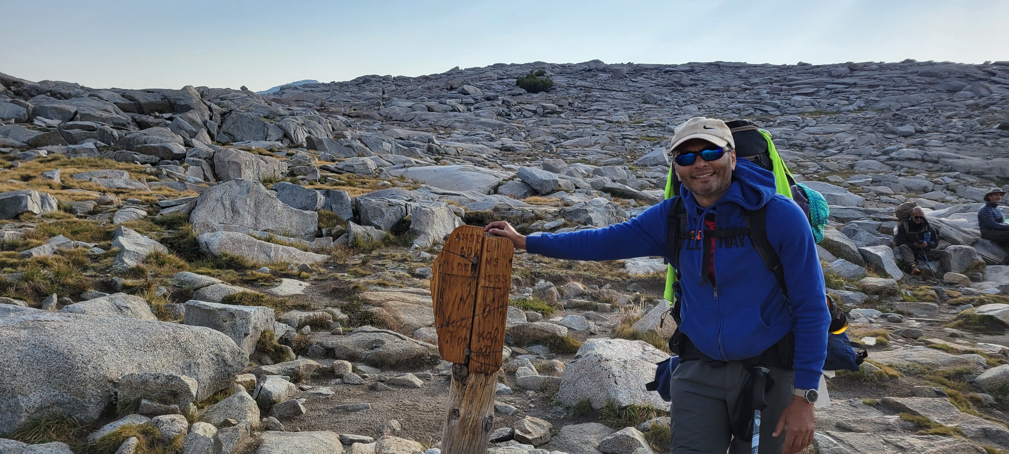
Devils Postpile National Monument is a U.S. National Monument located near Mammoth Mountain in Eastern California. The monument protects Devils Postpile, an unusual rock formation of columnar basalt. It encompasses 798 acres and includes two main attractions: the Devils Postpile formation and Rainbow Falls, a waterfall on the Middle Fork of the San Joaquin River. This National Monument lies within the borders of the Ansel Adams Wilderness. We did not go to Rainbow falls, instead detoured to Reds Meadows.

Saw tons of people at Devil's Postpile. It is accessible by car from Mammoth. So many people come there. After that it was a small uphill to Reds Meadows. It is accessible by car from Mammoth Lakes, CA, a ski and a mountain resort. We also met this lady call Crystal Gail who was doing a 6,875 mile Great Western Loop in the US. She is in the picture.

We reached at 1.15 pm 11.6 mi. Mostly downhill. Ate garden veggie burger for lunch and dinner. Took shower, did laundry. After 6 days was a pleasure not to have to cook or deal with bear canisters.

We picked up our food resupply for the next 5 days from Reds Meadows and arranged it in our backpacks.

We stayed in a comfortable room with bunk beds. Felt nice after so many days of tent sleeping.

At Reds Meadows, Arun Kumar had to leave the trek because his wife was undergoing medical treatment and he needed to be with her. Reds Meadows had easy exit access to Mammoth Lakes, CA by road. So it made sense for him to leave at Reds and go to Mammoth Lakes and then Reno to catch a flight back to Seattle. He was the strongest and most experienced member of the group who had done the most backpacking. We were really sorry to see him go.
Back to top of Day by Day Itinerary
Day 7: Reds Meadows to Purple Lake (13.6 miles)
Started at 5.45 am. We were totally packed the previous day. Lots of climbing till 10.15 am about 8.25 miles covered. We then waited for Ankur who came at 11.30 am.


We continued ups and downs. There was no water for 5 miles. Time after 12 noon becomes very exhausting. Views were quite nice though.


We reached at 3.10 pm. 13.6 miles, 3,200 ft climbing. I used to recite Ramraksha and Bhimarupi while climbing so that the climbing seemed easier. Purple Lake was quite beautiful with a campground very close to the lake.


We had to put up water filtration system up every day. Almost 4 liters of water per person to be filtered mainly for particulate matter. Jai, Ankur and Ashutosh had these filtration bags that could hold up to 6 liters and were very useful at campsites. Anu, Meenal and I had portable water filters which were useful for picking up water on the way during the actual trek.

Day 8: Purple Lake to Mott Lake Junction via Silver Pass (12.7 miles)
Woke up at 4.10 am ready by 6.00 am. Became efficient at getting ready. 1.7 mi climb to Virginia lake. Reached by 7.30 am. It was cold.


Few miles walk. Then started climbing Silver pass at 9 am. Squaw, Chief and Warrior lakes before the pass.


Finished climbing the 1700 ft pass at 12.30 pm. 3.3 mi in 3.5 hrs. We realized that while climbing we used to do about 1.25 miles per hour average.


On the way we met two 12 year olds who were doing the JMT. Pretty cool.

There are bridges like this built on the trail wherever it is likely that the creek will overflow and it might not be possible to wade through it or step over the rocks.

Had lunch at Silver pass lake at 12.30 pm. Started at 1 pm and climbed down 2400 ft, 2.9 miles to Mott lake junction. We saw some nice meadows on the way. Arrived at 3.15 pm.


Campsite was next to Mott creek. Three levels of tents. Cuppa noodles for dinner. We covered 12.7 mi and reached the 85.2 mi JMT marker. Still many miles to go. Anu did her customary stretching at the campground. All of us did stretching after reaching the campground so that we could recover quickly.

One small side note for Day 8 was that on this day, our original plan was to take Goodale pass (instead of Silver pass) to go to Vermillion Valley Resort (VVR). It is on Lake Edison and normally people take a small 2.8 mile detour from JMT and take a ferry across Edison Lake (about 5 miles) to go to VVR. We planning to spend Day 8 at VVR and an extra rest day at VVR. Since the water levels were low, the ferry was not running, the trek became longer. Moreover the back-benchers in the group (Samir, Ankur and Meenal) who were a little slow, so we began to cut down on any unwanted miles. So we decided to skip VVR and go directly to Muir Trail Ranch (MTR) via Silver pass.
Back to top of Day by Day Itinerary
Day 9: Mott Lake Junction to Bear Creek Trail (14.2 miles)
Started 6.20 am. Climbed down 2 mi to Mono creek. Reached Mono Creek by 8 am.


Then serious climbing for 3.3 mi, 2,000 ft. 65 switchbacks. Finished climbing at 10.30 am.


Climbed down till 12.15 and ate couscous for lunch at 12.15 pm. Finished lunch 12.45 pm. Saw some nice wildflowers on the way.


5 more miles left. Reached Bear Creek trail campground at 3.45 pm. 14.2 mi, 3,200 ft elevation gain.

At night we heard the jingling of cowbells in the night. We also heard running noises in the night. We guessed that it might be the mules that were going along the trail, but we were too scared to really come out.
Back to top of Day by Day Itinerary
Day 10: Bear Creek Trail to Muir Trail Ranch (via Seldon Pass) to Piute Creek (13.3 miles)
Woke up at 4.15 am. Left by 6.05 am.

Reached Marie Lake 1.7 mi at 7.30 am just below Seldon pass, 1500 ft climb.


Reached top of Seldon pass at 8.30 am.


After Seldon pass, Heart lake and then Sally keys lake.


Downhill 2,400ft and all the way for 6 miles to Muir Trail Ranch (MTR). We were enthused when we saw signs for Muir Trail Ranch. Reached by 12 noon. 10 mi total. We were planning to stay there and enjoy hot springs.


We picked up our resupply at MTR and arranged the food for the next 5 days.

We were getting ready to chill and enjoy the hot springs when Ankur suggested that we walk 3.3 extra miles to save time the next day. So we ended going to Piute creek campground in Piute canyon.

We did total 13.3 mi and reached at around 3.45 pm. 1500 ascent, 2400 descent Slept at 8 pm.


Covering these extra miles was a good idea because it meant fewer miles on the next day.
Back to top of Day by Day Itinerary
Day 11: Piute Creek to Evolution Lake (11.5 miles)
Started at 6.05 am We had entered the King's canyon national park.


Saw a waterfall. Took pictures at evolution creek. Kept ascending.


Flat track at Evolution valley and McClure meadow.


We also had to do a water crossing where we had to wade through the water. We removed our shoes, wore sandals and on the other shore, wore the shoes again. Took us almost 20 mins. Ankur simply waded through the stream with his shoes on. Typically, earlier in the season in June, July, there are many such streams that we would have had to wade through. But in August, we had to do this water crossing only once.

Meenal got lost. Looked for her for 1 hr from 11.30 to 12.30. She was waiting for us just ahead.

Started climbing at 12.30 pm. 1200 ft climb steep to evolution lake campground. Quite a bit of climbing.

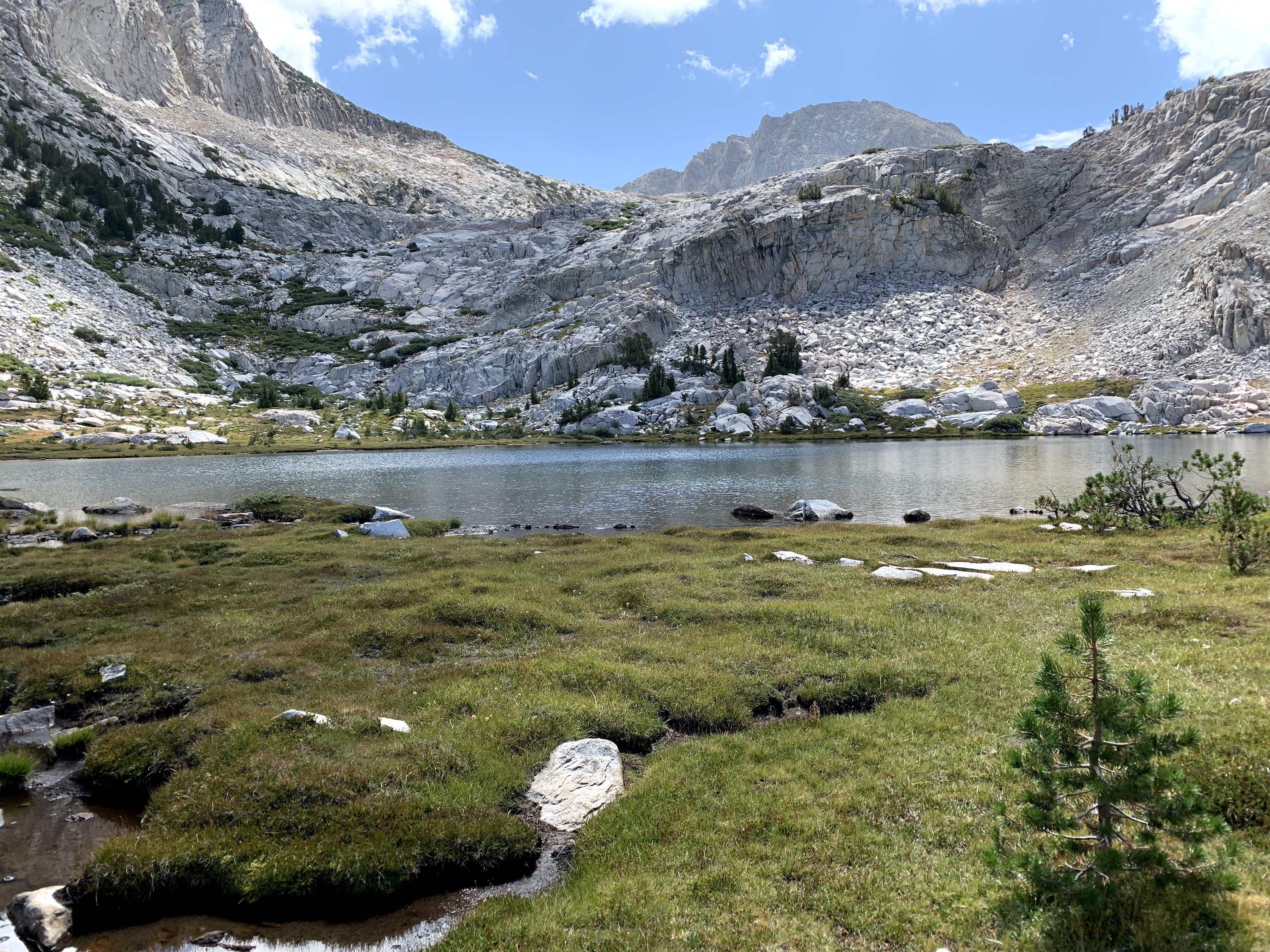
Reached Evolution lake at 2.45 pm. 11.5 mi, 3200 ft elevation gain. It was a beautiful location but very few trees and completely exposed to the sun.


Played Antakshari. Slept at 7.45 pm.
Back to top of Day by Day Itinerary
Day 12: Evolution Lake to Kings River Middle Fork via Muir Pass (14 miles)
Started at 6.30 am late. Started ascending towards Muir pass. Passed 1 mi long Evolution lake. Stunning pictures.


Wanda lake, really nice. Kept climbing and reached McDermott lake.


Reached Muir pass at 10.30 am after a 1500 ft 6 mi.
Climb to 11,969 ft at Muir pass. Muir hut shelter was built in 1931 at the top of the pass for hikers who may need respite from the elements. We took lots of pictures.


Meenal was very tired at the top of Muir pass and started crying after reaching. Out of relief from the anxiety of dealing with Muir Pass. We commended her on the fantastic climb.
Left Muir pass at 11 am. Started descent to Le Conte canyon 3200 ft. Lots of rocks initially . 8 mi descent. Hard on knees.


Reached campground at 3.45 pm. Very tired. 14 miles. 1500 ascent 3200 descent. Saw a family of deer at the campground.


Back to top of Day by Day Itinerary
Day 13: Kings River Middle Fork to Lower Palisades via Golden Staircase (10.9 miles)
Started at 6.05 am.

Mostly flat terrain with some up and down for 7 miles. Grouse Meadow. Blueberry patches. Rosemary bushes. Beautiful wildflowers.


Started climbing to the foot of the Golden staircase. The 3 miles of trail from Deer Meadow up to Palisade Lakes has been named the Golden Staircase. At twilight the canyon trail takes on a golden glow, but the seeming unending series of steps and switchbacks climbing more than 2,000 feet makes it among the most physically challenging sections of the John Muir Trail. Saw some nice views.

Started climbing Golden staircase at 7.8 miles. 3.1 miles to the top. 10.05 am to 12.45 pm. 1,800 elevation.


Reached Lower Palisades lake at 10,600 ft. Total 10.9 mi. 2,700 elevation gain.


Reached the campground at 12.45. Nice long lazy day. Played cards, game of Judgment. Had some fun too.


This is how we dried our clothes in the sun. We bathed only once at Reds Meadow during the trek. We used to wash our clothes every 4-5 days.

Back to top of Day by Day Itinerary
Day 14: Lower Palisades to Lake Marjorie via Mather Pass (12.3 miles)
Started at 6.05 am. Took our customary selfie.

Mostly flat terrain with some up and down for 7 miles.
Started 6.15 am. Immediately started climbing towards Higher Palisades Lake.

Passed the lake and continued climbing to Mather Pass at 12,100 ft.

3 mi 1600 ft climb. Reached Mather pass at 9.00 am Meenal reached 9.25 am. Met other people. Left at 9.45 am.

Long 6.5 mi 2400 ft descent to South Fork kings river at 9.5 mi. Had rajma chawal for lunch.

Started climbing towards Pinchot pass 1200 ft at 12.50 pm. Saw some beautiful lakes.

2.8 mi climb Reached Lake Marjorie campground at 2.40 pm. Total 12.3 mi, 2800ft elevation gain, 2400 elevation loss.

Back to top of Day by Day Itinerary
Day 15: Lake Marjorie to Woods Creek Junction via Pinchot Pass (9 miles)
6.20 am started from Lake Marjorie.

1.5 mi 1000 ft climb to Pinchot pass. Reached Pinchot pass top at 7.35 am. Meenal and Ankur joined soon after. Left at 8 am.


Long downhill 3000 ft 7.5 miles to Woods creek junction. Reached at 12.15 pm. Some really nice wildflowers.


Mule resupply was waiting. Tom had 1 horse and 2 mules (3 animal train). This was a very crucial resupply because it was on the trail. Also, the trail resupply option was expensive about $850 total for 6 people, but the other option was to go over Kearsarge pass to Onion Valley and that would have added one more pass and 15 miles.

Played cards, dumb charades. Ate idli for dinner. Campground is nice. Woods creek nearby
9 mi 1000 ft.

Mile marker 168 of JMT. The end of JMT now felt within reach.
Back to top of Day by Day Itinerary
Day 16: Woods Creek to Rae Lakes (7 miles)
Short day today. Woke up at 5.15 instead of 4.10 am. Left at 7.10 am.

Mostly ascent slightly up. 2100 ft climb 7 mi to Rae Lakes. The Rae Lakes Loop is one of the most popular hikes in Sequoia and Kings Canyon, if not in the entire Sierra. It is a very pretty location. The loop is 41.4 miles long, and climbs from 5035' (1535m) at the trailhead to 11,978' (3651m) at Glen Pass. Hikers from Southern California often do just the Rae Lakes loop if they do not want to do the entire JMT.


Meenal was feeling a little slow today but she finished strong to Rae Lakes. Reached by 12.15 pm.


Back to top of Day by Day Itinerary
Day 17: Rae Lakes to Bubbs Creek via Glen Pass (10.9 miles)
Started at 7.10 am.


Reached top of Glen pass at 9.00 am. About 2 mi, 1500 elevation gain.

Reached Charlotte Lakes junction 4.3 mi at 10.40. Mostly downhill. Picked up two fuel canisters from Tom at 11.05 am, mule train. He remembered and got us a matchbox.

Left Charlotte Lakes junction at 11.10 am and ate lunch at 12.20 pm in a wooded area.
Left at 12.45 and reached Bubbs creek at 2 pm.

1.9 miles left but mostly uphill towards Forester pass. Reached campground at 3.40 in hot sun. Walk after Bubbs creek was challenging in the sun.
Nice campground at 11,200 ft but still lots of trees and good access to a nearby stream.
10.9 mi, 3100 elevation gain, 2500 elevation loss.


Back to top of Day by Day Itinerary
Day 18: Bubbs Creek to Wright Creek via Forester Pass (12 miles)
Started at 6.10 am.


Climbed Forester' pass 1800 elevation gain over 3 miles. Reached at 8.40 am.
Meenal arrived at 9.10 am, she was overwhelmed and she cried. Forester pass is the place where King's Canyon ends and Sequoia national park starts.


Descending Forester pass at 9.20 am. 2400 ft descent. Reached Tindle creek at 12.15 pm. Meenal twisted her ankle and fell, but was ok. 7.9 mi from beginning. Ate lunch.


Left 12.45 with 3.1 miles left. Some climbing. Ankur, Meenal, Anu and Samir played contact. Reached campground at 2.20 pm. Total 12 mi, 2600 ascent, 2400 descent.

Back to top of Day by Day Itinerary
Day 19: Wright Creek to Guitar Lake (11.3 miles)
Started at 6.10 am.

Reached Crabtree ranger station at 9.00 am. Pooping in the Whitney Protected Area is not allowed. So the only way to go toilet is to use a wag bag. Picked up wag bags for toilet use at Guitar lake.

Passed Timberline Lake.

Continued on to Guitar lake, really shaped like a guitar. Continued 0.4 miles beyond to the tarn, a small pond 200 ft above guitar lake.

Reached our campsite at 11.15 am. Prepared for the Whitney Summit ascent the next day. Lasagna for dinner.


Back to top of Day by Day Itinerary
Day 20: Guitar Lake to Whitney Portal via Mount Whitney (15.4 miles)
Woke up at 12.30 am on Monday Aug 30. Started climbing towards Whitney trail crest at 1.40 am. Climbing in the dark with head lights on. Ankur, Meenal and I climbed together. Jai, Ashutosh and Anu started at 2.30.


Reached Trailcrest at 2.2 mi 1800 ft at 4.23 am. We kept our backpacks there and started climbing towards whitney 1.9 mi, 1200 ft.

Reached Mt. Whitney top at 6.10 am. Day break was at 5.57 am and sunrise at 6.20. We took a lot of pictures, sense of exhilaration for the entire team.


Started coming down at 7.03 am. Reached Trailcrest at 8.15 am. Picked up our backpacks and had 8.7 mi left. There was a brutal descent where we had to climb down 99 switchbacks (Imagine climbing those!). We had decided to go directly to Whitney portal going down 8.9 additional miles and climbing down 6,400 ft.


Reached Whitney portal by 1.45 pm. There was real joy on everyone's face.

We ate burger and lots of fries at Whitney portal. A van picked us up and took us to Lone Pine. Stayed at a The Trails motel in Lone Pine. Pretty good motel.
As we descended to Lone Pine, we also learned that due to California fires, as of Aug 31, 2021, all National Parks and Forests were being shut down. Any hikers who were on the trail were being evacuated. We got really lucky that we completed our entire JMT trek, 1 day before the parks got closed. We met many hikers who had planned everything and now had to abandon the trek due to fire evacuation.
Back to top of Day by Day Itinerary
Return to SFO Bay Area
We returned to the San Francisco Bay Area on Tue, Aug 31. We took a bus from Lone Pine to Mammoth Lakes airport where we picked up a rental car from National. Interestingly, the airport was closed but National Car Rental was the only counter open at the airport. Luckily, we got our rental. We started driving at about 11 am from Mammoth Lakes and reached Sunnyvale at 6 pm.

We were given a very warm welcome by Jai's family.

Back to top of Day by Day Itinerary
End of the JMT Experience
Thus ended a fantastic and unique experience that we would remember for a lifetime.

3 comments
Hi Samir,
ReplyDeletei regularly follow your adventure and As usual this was a great adventure.
Quick comment: in the youtube video at 37 min mark you have put the driving license in clear. It's not recommended to do that as it can result in ID theft.Please obfuscate it if possible.
You can clear off this comment after that.
Thx
Bhupinder Misra
The blog is very detailed and immersive .... I almost felt I was there...
ReplyDeleteएका अप्रतिम ट्रेक चे खूप detail वर्णन. सुंदर marking, अप्रतिम लोकेशन, अप्रतिम फोटो आणि अप्रतिम camping ची सोय.
ReplyDeleteब्लॉग मधील details मुळे मी पण ट्रेक केला असे म्हणू 😀शकतो.
Samir आणि सर्व टीम मेंबर्स चे अभिनंदन